The most common mistake we see in Sudbury is assuming bedrock is uniform just because the outcrop looks solid at surface. Glaciofluvial deposits here can mask deep troughs, and the contact between overburden and the underlying Shield granite is rarely a flat plane. When a contractor sinks an excavation based only on a few boreholes, they miss the lateral gaps. Vertical Electrical Sounding fills those gaps. By injecting current into the ground and measuring the potential drop across a expanding array, we construct a continuous resistivity profile that reveals where clay pockets, saturated silts, or fractured rock zones actually sit. For projects near the Sudbury Basin rim, where sulfide mineralization alters groundwater conductivity, this method helps us separate natural anomalies from real geotechnical hazards before a single bucket hits the soil.
Resistivity doesn't just map layers—it discriminates between clean sand, contaminated clay, and fractured rock by how each conducts current.
Our approach and scope
Site-specific factors
The contrast between the Flour Mill area and the newer subdivisions south of Long Lake Road tells a clear story. In the Flour Mill, historical fill mixed with tailings from early smelting creates a conductive layer that can mask underlying bedrock depressions. Down south, clean sand and gravel outwash from the Vermilion River delta behaves as a resistive medium, making clay lenses stand out sharply. If a project in the western basin relies only on borehole spacing typical of southern Ontario, it misses these abrupt transitions. We've seen cases where a strip footing designed for 150 kPa bearing on sand encountered a 2-meter-thick clay seam at 4 meters depth—undetected until the footing tilted. A VES survey across the same pad would have flagged that low-resistivity anomaly in a single afternoon. When your site sits on the complex stratigraphy left by the retreat of the Superior lobe, skipping a resistivity profile means betting the foundation on a guess.
Reference standards
ASTM D6431-18 (Standard Guide for Using the Direct Current Resistivity Method), NBCC 2020 (National Building Code of Canada, geotechnical investigation requirements), CSA A23.3 (Design of Concrete Structures, references to site characterization)
Complementary services
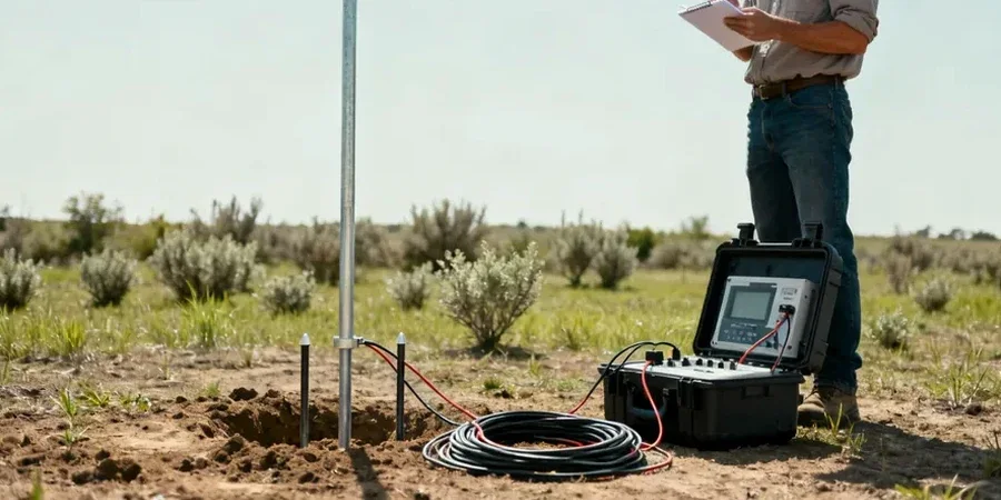
1D Vertical Electrical Sounding (VES)
Single-point Schlumberger sounding to determine layer thickness and resistivity values at a target location. Ideal for preliminary foundation depth assessment.
2D Resistivity Imaging
Multi-electrode Wenner or dipole-dipole line for mapping lateral changes along a transect. Used for pipeline corridors and road cuts in the Sudbury Basin.
Borehole-to-Surface Tomography
Combines downhole electrodes with surface arrays to resolve thin layers in complex overburden sequences, particularly effective in glaciofluvial settings.
Time-Lapse Resistivity Monitoring
Repeated surveys to track groundwater movement or contaminant plume migration over time, referenced against baseline VES data.
Typical parameters
Frequently asked questions
How much does a VES survey cost in the Sudbury area?
A typical Vertical Electrical Sounding campaign ranges between CA$900 and CA$1,240, depending on the number of sounding points, maximum depth needed, and terrain accessibility. Projects requiring multiple lines or winter access equipment fall toward the upper end.
How deep can resistivity surveying reach in Northern Ontario soils?
With our 400-watt transmitter and Schlumberger array, we routinely reach 50 to 80 meters in Sudbury's glacial deposits. Frozen ground in winter reduces current injection efficiency, so we use saline coupling and a high-voltage booster to maintain depth penetration during cold months.
Can resistivity tell the difference between bedrock and a boulder bed?
Not always on its own. A dense boulder layer can show resistivity similar to fractured bedrock. That's why we cross-reference VES profiles with seismic refraction or borehole data when the resistivity curve shows an ambiguous high-resistivity layer near the expected bedrock depth. More info.